“It is good to have an end to journey toward; but it is the journey that matters, in the end.” ― Ernest Hemingway
Tuesday, October 22, 2013
Saturday, September 21, 2013
Day 15 GPS
The boy was up shortly after and we made our tea amd packed up camp before one last stroll on the beach.
I could have only imagined the hugeness (yes thats a word) of Lake Superior last night in the dark. And it didn't compare to the actual vision of the lake. Its more like a small non-salty ocean with waves and currents and tides. Today with the chopped and heavy surf I didn't dare to stick my big toe in.
A 1.5 mile walk down one of the many trails will take you to a lighthouse with many shipwrecks and artifacts about. Next time we will visit. So cool.
Then off headed south through the U.P. to Grossw Ile for dinner with TJ's parents.
Back throuth the windy route 58 then 2 south and over the Macinac Bridge. The longest suspension bridge in the US. Or something like that. A quick (or not so quick as the case may be) stop for lunch then Grosse Ile.
We had a lovely dinner with TJs parents and one more stop to crash at Jeff & Lauras for our last night on this epic journey. I almost dont want it to end. We really have had an awesome trip. I miss the boys though. It will be good to see them in the wee hours of the morning Monday.
Powered by Breadcrumbs: manage, edit and share GPS tracks for free.
Day 14 GPS
Another day of driving behind the rain. Picking up sprinkles here and there. Another day of overcast and below average temps.
Up and in the car before noon. Excited for our last day of camping on our trip on Lake Superior. The scenery has changed from prarie and scrub to forest. Very Maine looking but the fall colors are already on display. A bit ahead of Southern Maine.
A longer drive than anticipated again on winding roads in the U.P. There is no exaggeration about the deer population. As soon as the light started to wane. Deer, deer, deer. And so on. We counted 6 or so in just a couple of miles.
But we made it in time to make a fire, have dinner and take a walk on the beach. The beach looked like any other beach on the ocean. Sand, debris washed up, waves, wind... but the fact that it is a lake blows my mind. We read fact s about it on the way to entertain ourselves which made us more in awe while there.
Tomorrow Detroit. Home in less than 48 hours. What a trip!
Powered by Breadcrumbs: manage, edit and share GPS tracks for free.
Lake Superior, Michigan
Yesterday we crossed into (and through) our last of the 22 states we're touching on this trip. Wisconsin was Wisconsin, not looking too dissimilar from upper Minnesota. Then darkness fell and we passed back into Michigan, this time into the upper peninsula. Pictured Rocks National Seashore was our stopping point for the night. We were hoping to find our campsite by 8 but didn't do so until 11, but that didn't dampen our spirits. We checked out the lake (it's huge and had surfable waves) and got wet, then started a fire and set up camp. Sauteed cheddar brats in chili were the bites du jour, hoping it would keep us warm in the early-morning hours. It did.
This morning marks another end to our journey. We've finished our leg to Route 66, then finished 66 itself, then finished the Pacific coast, and now we're ending our two weeks of camping. Tonight will be spent in a warm bed in Michigan and tomorrow night we should be home in Maine.
Friday, September 20, 2013
Minnesota
Woke up in the Chippewa National Forest along Cass Lake in mid Minnesota. It rained overnight, again. That same weather pattern that has been playing "Tag" with us cross-country gave our tent a late night kiss on the rain fly, capping off a beautiful night under the starry sky. We're packed up and ready to head for our next stop, the Pictured Rocks National Seashore, along the banks of Lake Superior in Michigan's Upper Peninsula.
Day 13 GPS
Woke up in the beautiful landscape of Teddy Roosevelt National Park full of painted rock views. Packed up quickly because although the night had been dry, the rain was knocking and wanted in.
Again heading west on Route 94 we set out. Not sure where to yet. We passed alot of open field. Some crops some scrub on the straightest road ever. It seemed to go on and on.
We made it to Fargo ND and stopped for dinner and a taste of yet another local beer. We sat at the bar as we usually do at Granite City Brewery. As two of the bartenders worked and chatted with us on the side. We were in local dialect heaven. Each word rung true to the exaggerated speech that you hear in movies. We sat and ate and giggle our way through dinner. As we were finishing up one, Ashley, of the bartenders (who asked us our names at the start and actually remembered it) spoke the magic words. "Blah blah blah LAKE VERMILLION" The conversation seemed to stop. TJ interjected with his childhood memories of the lake. A seemingly innocuous comment and a connection made. Yup we left with a beautiful growler of thier IPA and a gifted Granite City Brewery mug from Ashley. So sweet. Another moment when life parrallels BM. But that is a long tale saved for another post. See, this was our BM trip and so many things have happened as if we were on playa.
We picked our evening spot of Chippewa National Forest while at dinner. Just before Grand Rapids MN. A couple of options to camp. Found a site on the Chippewa Camp Loop. Right on the water. Probably the best campsite yet. Set up camp and took a walk on the water under the bright full moon. Beautiful.
Powered by Breadcrumbs: manage, edit and share GPS tracks for free.
Thursday, September 19, 2013
Cass Lake, Minnesota
Next stop: Cass Lake, in the Chippewa National Forest, Minnesota. It's already dark when we arrive at 11pm but I can tell this is going to be a beautiful campsite. Plenty of space, fire pit, a picnic table, and a walkway right to the lake's edge. Splitting hairs I'd say the full moon is tomorrow but it sure looks full tonight, reflections spraying with the crashing waves' mist, like a rainbow in the dark. Tomorrow I swim.
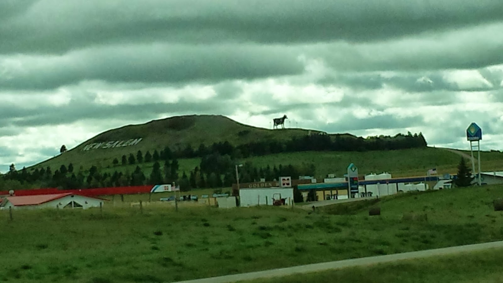
Today was a drone of driving. We did see a few interesting things, like the "World's Largest Holstein Cow". It was visible from the freeway and the townsfolk were below in the immediate path, should the behemoth Bessie decide to flee for greener pastures. But she kept watch over her human flock as we drove past, slipping out of sight around the next bend.
Tomorrow we plan to explore Minnesota and possibly visit Lake Vermillion, my Grandmother's escape from the real world. I remember it for its red-cabin-in-the-woods feel, its educational dock, and of course, the sauna. Oh yes, the sauna. The Finns' original man cave. The place where 250 lb men are no match for fire-bred steam and little old ladies find relief from the arthritic advancement of time. But I was neither. I was just a life-loving little kid who loved to roast in the sauna before jumping into the lake. I can still feel my pores slamming shut and the slippery rocks at the bottom of the lake. Hopefully I will feel those same rocks tomorrow, but there is a problem: no address. I will be trying to use 43-year-old brain cells to reconstruct memories from before video games. Before computers. Before sex became "safe" and Halloween became "dangerous." Before I realized that I may never see that red cabin in the woods again. This sounds like an adventure just waiting to happen.
Day 12 GPS
Longest day ever! Wow never felt so good to sleep last night at 3:30 am. I digress...
The rain has been threatening and just ahead of us going east. We caught some as it was getting dark and it was not fun. Hopefully we loose it.
TJ drove and drove. I dozed in and out. There were pee stops and lots of trucks. We had a good dinner at the Iron Horse pub in Missoula, Montana. I think... Missoula.
Then we drove and drove. Did I mention we drove alot yesterday?
Camping was nice in the park. We were greeted by a doe upon our entrance. She kinda meandered out and across slowly as if to say hi.
Powered by Breadcrumbs: manage, edit and share GPS tracks for free.
Day 11 GPS
We headed in to Seattle proper to meet up with Maggie. We had a yummy lunch at Griddle and went to see the locks that seperate the freshwater lake from the Puget Sound. Interesting to see the boats go up and down. We timed it just right and watched a tour boat decend to Puget Sound. We got the whole audio tour. Perfect timing. Noah and Maggie are doing well. Bear their dog has a few issues though. He was really friendly with TJ and I....if you know what I mean. ;) We had a good laugh at his expense, a short hello to Noah over the phone and we were off again.
Powered by Breadcrumbs: manage, edit and share GPS tracks for free.
"World's largest metal sculpture"
We haven't yet seen the world's largest ball of yarn, but the roadside sign claims that this is the world's tallest metal sculpture. It's pretty, but I'd bet that Burning Man might be able to challenge the title.
Stella isn't going to like this
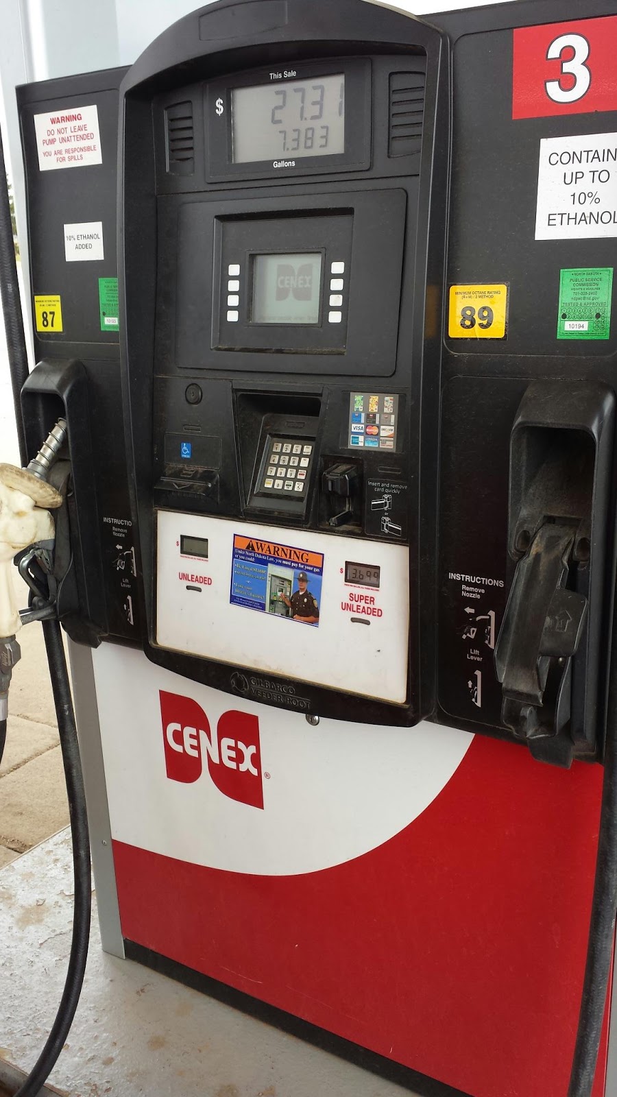
Deanna had to make a pit stop, so we pulled into a gas station in North Dakota. Cool I thought, until I started filling with Premium, only to realize that in North Dakota apparently "Premium" means 89 octane. And 10% ethanol. I'd rather pay the $4.30 for 93 octane and no corn, but there aren't many options out here. On we go...
Theodore Roosevelt National Park
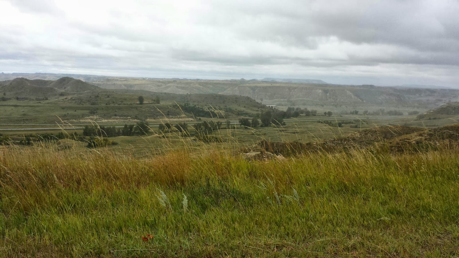
Woke up this morning in Theodore Roosevelt National Park. It's just east of the Montana-North Dakota border and a long drive from our last stopping point, the KOA in Spokane, WA. 825 miles to be exact. It was good to get some more miles under us as we've been slacking on the mileage for the last several days,ionly a few hundred at a time. Although fewer they've been good miles, full of twisty roads and beautiful views. But two days ago we turned the ship eastward, our time on the West Coast having drawn to a close. Time to move on.
We drove all the way through Idaho and Montana in one day. Not that I really wanted to do so, as they are two states that I really wanted to explore. But we're on a time budget, so we're trying to keep on track. Beautiful as I'd expected, it will likely be its own destination in the future. Maybe when I get my full pilot's license, as there seems to be way too much to explore by land.
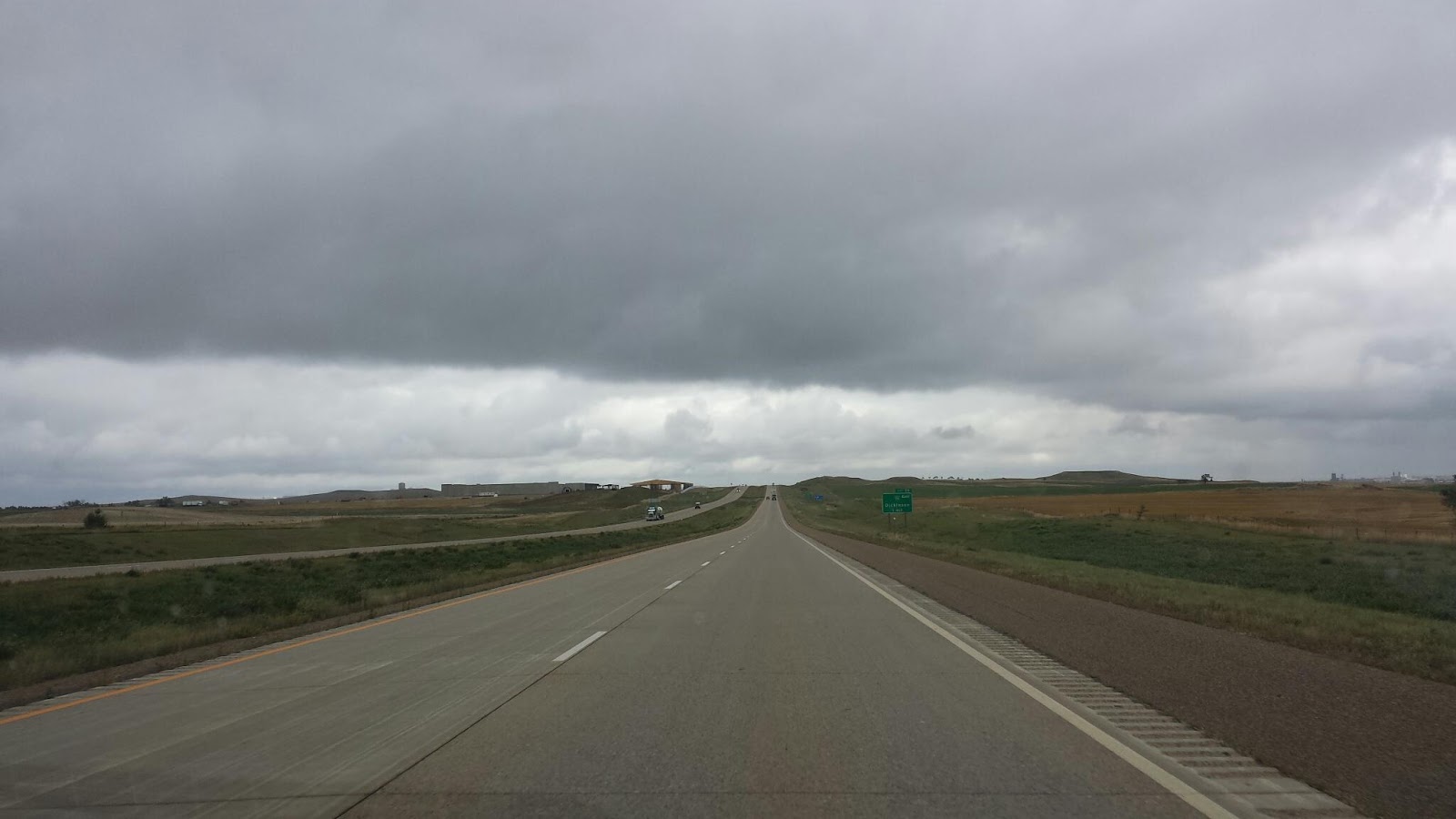
We could have gone through North Dakota or South Dakota but we chose the Northerly option. Why? For a few reasons. First, Google Maps and Waze and my car's navigation all agreed that it would be the best route to Escanaba, our first Michigan waypoint. Second, I'm hoping that we can make it to Lake Vermillion in Minnesota, the site of my grandmother's cabin, where I spent many a summer vacation as a little kid. Third, we're trying to avoid the South Dakota curse. In Seattle, Maggie told us her tale of woe. She and Noah had done a similar road trip, making it all the way to South Dakota before the spousal tolerance began to wane. We're hoping to avoid a similar fate.
Tuesday, September 17, 2013
Day 10 GPS
Powered by Breadcrumbs: manage, edit and share GPS tracks for free.
Day 9 GPS
Powered by Breadcrumbs: manage, edit and share GPS tracks for free.


